Radars in space is proving to be one of the most useful methods of Earth observation from high above! Using microwave radiation that bounces back from the Earth's surface, not only scientists and geologists can beat the clouds and atmospheric turbulence that optical/infrared images cannot escape from, they could also find sub-surface and sub-vegetation natural and man-made structures that are not easily found even when investigating in-situ. Therefore since the launch of the first civilian use radar satellite, SeaSat 1 in 1978, radar's usefulness in Earth orbit has proven to be substantial from environmental surveys to urban planning and disaster relief. No wonder multiple space agencies worldwide are now operating different types of radars in space to meet scientific, government and commercial needs.
Only 7 weeks after ESA receives its newest radar Earth observation satellite - Sentinel 1A - it is JAXA's turn to launch one using the most advanced technology available.
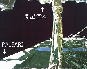
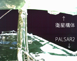
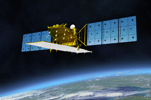
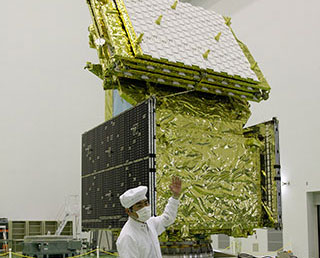
ALOS-2 (Advanced Land Observing Satellite-2), named Daichi-2 (Great Land-2), is the 3rd generation L-band radar satellite of Japan's space agency. Replacing the radar component of the original ALOS "Japan's Envisat", which was in operation from 2006 to 2011, this radar satellite has a rather interesting difference from the many other general use radars in operation - the frequency the radar is operating.
While most others uses higher frequency microwaves in the C-band (4-8 GHz) (e.g. ESA's Envisat/Sentinel-1, Canada's RADARSAT series) or the even higher X-band (8-12 GHz) (e.g. Germany's TerraSAR-X/TanDEM-X, Italy's COSMO-Skymed), ALOS-2 goes for lower frequencies in the L-band (only 1-2 GHz). While this lowers the maximum resolution of the radar ("only" about 3 meters for ALOS-2 and 10 meters back on ALOS, compared with <1 meter for X-band satellites), it also means that it could go though clouds, rain and leaves/branches of vegetation completely and reflect from the ground surface, something that can't be done by higher frequencies microwaves! One major use of this unique capability, for example, is to monitor the small movements of the Earth's crust for prediction of earthquake and volcanic activities and surveying their aftermaths - down to 2.5 cm accuracy for one sweep and even down to millimeters after several measurements!
Other than that though, while it is not quite suitable for urban surveying tasks (such are usually performed by X-band ones), it is good enough in the other areas that it could fulfill these major tasks:
1) Disaster monitoring of damaged areas in considerable detail and in large areas
2) Continuous updating of data archives related to national land and infrastructure information
3) Effective monitoring of cultivated areas
4) Global monitoring of tropical rain forests to identify carbon sinks
So good luck with getting to space! The world needs you!

Launch site:|Pad 1, Yoshinobu Launch Complex, Tanegashima Space Center, Japan
{colsp=2}
[highlight]L[eventtimer]2014-05-24 03:05:14;%c%%ddd%/%hh%:%mm%:%ss%[/eventtimer][/highlight]
Payload:ALOS 2 (Advanced Land Observation Satellite 2) is a planned radar Earth observation satellite to be used for cartography, regional observation, disaster monitoring, and resource surveying. It is the follow up to the radar component of ALOS (Daichi).
The state-of-the-art L-band Synthetic Aperture Radar (SAR) aboard ALOS-2, which is an active microwave radar using the 1.2 GHz frequency range, will, in responding to society's needs, have enhanced performance compared to DAICHI/PALSAR. The SAR is capable of observing day and night, and in all weather conditions.
ALOS-2 will have a spotlight mode (1 to 3 m) and a high resolution mode (3 to 10 m), whilst PALSAR has a 10 m resolution. It will allow comprehensive monitoring of disasters by providing users with more detailed data than DAICHI/PALSAR. The observation frequency of ALOS-2 will be improved by greatly expanding the observable range of the satellite up to about 3 times, through an improvement in observable areas (from 870 km to 2,320 km), as well as giving ALOS-2 a right-and-left looking function, currently not available on DAICHI/PALSAR.
Mass:
|
- 2120 kg
Power:
|
- 5.2 kW
Lifetime:
|
- 5+ years
Orbit:
|
- 628 km circular SSO
Inclination:
|
- 97.9 degrees

In addition 4 cubesats from various Japanese institutions are carried on this flight. (more on that later)
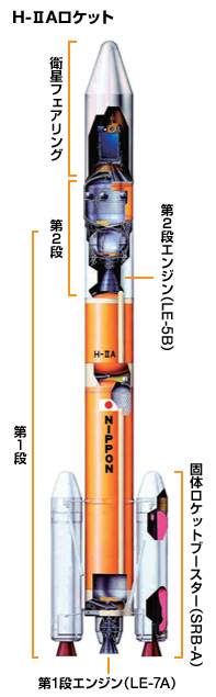
Launch Vehicle:The 24th flight of the H-IIA Launch Vehicle (H-IIA F24) is an "H2A202" type with two solid rocket boosters (SRB-As) attached. The 4S (4 m in diameter) type fairing is used.
Live coverage of the launch:
- JAXA webcast
(starts at 02:15 UTC / 10:15 pm EST)
Weather Forecast for Nakatane, Japan on May 24, 2014 (12 p.m.)
Sunny to partly cloudy. High 20C. Winds ESE at 15 to 25 kph.
12 PM|20°C|12°C|73%|3%|0%|2%|1020 hPa|13 km/h ESE|
Links:
- Advanced Land Observing Satellite-2 "DAICHI-2" (ALOS-2)
- ALOS-2 brochure (PDF)
- ALOS-2 launch press kit (PDF)
- eoPortal: ALOS-2
- ALOS-2
Launch Sequence:
1.
|Liftoff|
0:00
|
0
|
0.4
2.
|Solid rocket booster burnout*|
1:55
|
47
|
1.6
3.
|Solid rocket booster jettison**|
2:05
|
55
|
1.7
4.
|Payload fairing jettison|
4:30
|
150
|
2.1
5.
|1st stage engine (main engine) cutoff (MECO)|
6:36
|
299
|
3.2
6.
|1st and 2nd stages separation|
6:44
|
311
|
3.2
7.
|2nd stage ignition (SEIG)|
6:50
|
320
|
3.1
8.
|2nd stage engine cutoff (SECO)|
15:14
|
633
|
7.5
9.
|ALOS-2 separation|
16:04
|
633
|
7.5
10.
|RISING-2 cubesat separation|
25:00
|
641
|
7.5
11.
|UNIFORM-1cubesat separation|
29:10
|
647
|
7.5
12.
|SOCRATES cubesat separation|
33:20
|
651
|
7.5
13.
|SPROUT cubesat separation|
37:30
|
654
|
7.5
*) Moment of combustion pressure reaching 2% of maximum
**) Thrust strut cutoff

The current view on Tanegashima Space Center (webcam). *

* This picture is automatically updated at intervals.
You need to reload the page to see the latest image.[/QUOTE]
* This picture is automatically updated at intervals.
You need to reload the page to see the latest image.[/QUOTE]


")