Wait, we have an Orbiter Beta 2017 already? That was fast.
No. We have a beta that was committed in 2017. Subtle semantics, but big difference. In fact, it shouldn't really be called a beta. Just call it a commit.
Wait, we have an Orbiter Beta 2017 already? That was fast.
The second one is a bit more intricate. The elevation grid Orbiter uses for computing vessel elevations, shadow normals, etc. is not necessarily the same as used for rendering the surface. For example, at high altitude, Orbiter doesn't use the highest available resolution tiles for computing altitudes, because that would require loading a new tile at each frame for each vessel. Even at low altitudes, the tile resolution may be capped to avoid too many reloads. However, this may require more fine-tuning. The question has come up before, and it's on my to-do list.
OK, so what we see and what the vessel "fells" might be 2 different surface resolutions, right? So if it's a feature and not a bug, for me to do a terrain elevation edit, and avoid that feature, I'd have to (somehow) propagate that edit up to the root tile, correct?
I can't see the Apollo landing site labels when I have "cache first, then archive" option selected. With "archive only" it all shows up.
Revision: 69
Author: martins
Date: 2017-09-01 03:15:09
Message:
Bug fix: new style surface labels would not render when quadtree policy was set to cache+archive
New style surface labels: font size adapted to distance and level
----
Modified : /Modules/Server/orbiter.exe
Modified : /Orbiter_ng.exe
Modified : /Orbitersdk/lib/Orbitersdk.lib
Modified : /Orbitersdk/lib/orbiter.lib
Modified : /orbiter.exe")
Shouldn't that be fixed by revision 69?
Code:Revision: 69 Author: martins Date: 2017-09-01 03:15:09 Message: Bug fix: new style surface labels would not render when quadtree policy was set to cache+archive New style surface labels: font size adapted to distance and level ---- Modified : /Modules/Server/orbiter.exe Modified : /Orbiter_ng.exe Modified : /Orbitersdk/lib/Orbitersdk.lib Modified : /Orbitersdk/lib/orbiter.lib Modified : /orbiter.exe
At least it works for me
I'm pretty sure you've got the according Label.tree files, right?
. They show up correctly in D3D9, so I'd say it's a MOGE issue.C 10.65 122.23333 Valencia
C 10.65 122.23333 Uayang
C 10.65 122.23333 Tugura-ao
C 10.65 122.23333 Tigmalapad
C 10.65 122.23333 Tigbagacay
C 10.65 122.23333 Tig-apog-apog
C 10.65 122.23333 Tig-amaga
C 10.65 122.23333 Ticdalan
C 10.65 122.23333 Tatoy
C 10.65 122.23333 Saring
C 10.65 122.23333 Sapa-Miagao
C 10.65 122.23333 San Fernando
C 10.65 122.23333 Quirayan Sur
C 10.65 122.23333 Quirayan Norte
C 10.65 122.23333 Pungtud Naulid
C 10.65 122.23333 Pungtud Ilaya
C 10.65 122.23333 Pudpud
C 10.65 122.23333 Potrido
C 10.65 122.23333 Oya-oy
C 10.65 122.23333 Onop
C 10.65 122.23333 Nasonogan
C 10.65 122.23333 Narorogan
C 10.65 122.23333 Nam-o Ubus
C 10.65 122.23333 Nam-o Tacas
C 10.65 122.23333 Naclub
C 10.65 122.23333 Maringian
C 10.65 122.23333 Maninila
C 10.65 122.23333 Mambatad
C 10.65 122.23333 Madoyo
C 10.65 122.23333 Lumangan
C 10.65 122.23333 Lanutan
C 10.65 122.23333 Ipuro Barire
C 10.65 122.23333 Indag-an
C 10.65 122.23333 Ilog-ilog
C 10.65 122.23333 Igsoligue
C 10.65 122.23333 Igpuro
C 10.65 122.23333 Igpangdan
C 10.65 122.23333 Igpajo
C 10.65 122.23333 Igdulaca
C 10.65 122.23333 Igdalaquit
C 10.65 122.23333 Igcatambor
C 10.65 122.23333 Igbugo
C 10.65 122.23333 Igbita
C 10.65 122.23333 Guibuñgan
C 10.65 122.23333 Gines
C 10.65 122.23333 Frantilla
C 10.65 122.23333 Dingle
C 10.65 122.23333 Diday
C 10.65 122.23333 Dalite
C 10.65 122.23333 Calagtañgan
C 10.65 122.23333 Caitib
C 10.65 122.23333 Cadoldolan
C 10.65 122.23333 Cabangcalan
C 10.65 122.23333 Cabang
C 10.65 122.23333 Cabala-unan
C 10.65 122.23333 Bugtong Lamangan
C 10.65 122.23333 Buenavista
C 10.65 122.23333 Bolocaue
C 10.65 122.23333 Belen
C 10.65 122.23333 Bagumbayan
C 10.65 122.23333 Bacauan
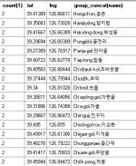
C 10.65 122.23333 AguiauanIf I can't find a solution for this, I could simply try to select a single label for any multi-assigned locations.

[U][B]Grouped by lat, lng, lvl & type:[/B][/U]

76779 times  2 equal positions
11222 times  3 equal positions
 3186 times  4 equal positions
 1189 times  5 equal positions
  579 times  6 equal positions
  290 times  7 equal positions
  171 times  8 equal positions
  138 times  9 equal positions
   91 times 10 equal positions
   51 times 11 equal positions
   44 times 12 equal positions
   26 times 13 equal positions
   23 times 14 equal positions
   21 times 15 equal positions
   11 times 16 equal positions
   11 times 17 equal positions
    8 times 18 equal positions
    7 times 19 equal positions
    6 times 20 equal positions
   10 times 21 equal positions
    7 times 22 equal positions
    5 times 23 equal positions
    3 times 24 equal positions
    3 times 25 equal positions
    4 times 26 equal positions
    1 times 27 equal positions
    3 times 28 equal positions
    2 times 30 equal positions
    1 times 31 equal positions
    2 times 32 equal positions
    1 times 36 equal positions
    1 times 42 equal positions
    1 times 46 equal positions
    1 times 55 equal positions
    1 times 62 equal positions


[U][B]Grouped by lat, lng & lvl:[/B][/U]

82913 times  2 equal positions
13140 times  3 equal positions
 3861 times  4 equal positions
 1579 times  5 equal positions
  755 times  6 equal positions
  373 times  7 equal positions
  234 times  8 equal positions
  154 times  9 equal positions
  114 times 10 equal positions
   70 times 11 equal positions
   54 times 12 equal positions
   32 times 13 equal positions
   30 times 14 equal positions
   20 times 15 equal positions
   13 times 16 equal positions
   12 times 17 equal positions
    7 times 18 equal positions
    8 times 19 equal positions
    7 times 20 equal positions
   11 times 21 equal positions
    8 times 22 equal positions
    5 times 23 equal positions
    2 times 24 equal positions
    3 times 25 equal positions
    5 times 26 equal positions
    4 times 28 equal positions
    2 times 30 equal positions
    1 times 31 equal positions
    2 times 32 equal positions
    1 times 36 equal positions
    1 times 42 equal positions
    1 times 46 equal positions
    1 times 55 equal positions
    1 times 62 equal positions


[U][B]Grouped by lat & lng:[/B][/U]

94691 times  2 equal positions
16773 times  3 equal positions
 5266 times  4 equal positions
 2194 times  5 equal positions
 1017 times  6 equal positions
  517 times  7 equal positions
  300 times  8 equal positions
  182 times  9 equal positions
  141 times 10 equal positions
   91 times 11 equal positions
   57 times 12 equal positions
   40 times 13 equal positions
   30 times 14 equal positions
   28 times 15 equal positions
   15 times 16 equal positions
    6 times 17 equal positions
   13 times 18 equal positions
    9 times 19 equal positions
    7 times 20 equal positions
    6 times 21 equal positions
   11 times 22 equal positions
    8 times 23 equal positions
    1 times 24 equal positions
    5 times 25 equal positions
    3 times 26 equal positions
    1 times 27 equal positions
    3 times 28 equal positions
    2 times 29 equal positions
    3 times 31 equal positions
    1 times 32 equal positions
    1 times 33 equal positions
    1 times 36 equal positions
    1 times 38 equal positions
    1 times 43 equal positions
    1 times 47 equal positions
    1 times 55 equal positions
1 times 62 equal positionsOk, so my source for the Earth labels (except the airport labels) is this:http://download.geonames.org/export/dump/
")