
The Sun. The ultimate source of energy that powers everything we have. The only star close enough for us to inspect its details. The brightest thing we have ever seen in front of our eyes.
Yet our understanding of its behavior is still very little, especially on its surface (known as the photosphere) - the region where energy from nuclear fusion brought along through convection inside the ball of hydrogen gas is transformed into heat and radiation. This is also where the complex magnetic fields and plasma caused the gigantic outbursts of gas and particles that we call the corona and heliosphere, as well as the solar wind that got blown out all across the solar system.
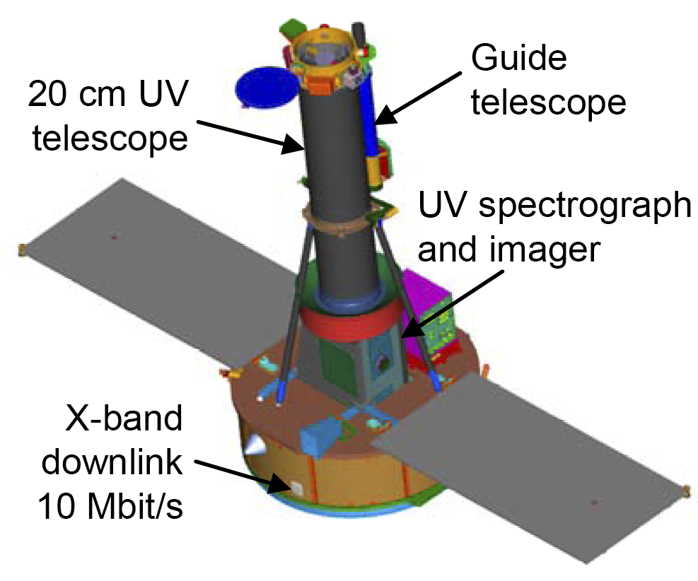
The Interface Region Imaging Spectrograph, NASA's newest small-scale astronomy mission, will be investigating this intriguing region of the Sun from a low Earth polar orbit. Equipped with an ultraviolet imaging spectrometer and a 20 cm ultraviolet telescope, the satellite will serve as the "microscope" of the surface of the Sun, and promises to improve our understanding of how solar flares, mass ejections and the solar wind is formed.
The 183 kg spacecraft will be riding on one of the most iconic rockets available today - Pegasus XL, the only sir-dropped space launch vehicle of today. The Pegasus XL is scheduled to be dropped from its carrier aircraft (a Lockheed L-1011 Tri-star) at 02:27 UTC tomorrow (7:27 pm PDT today) after taking off from Vandenberg Air Force Base in California.
Launch dates and times:
[table="head"]{colsp=6}Launch times
Time Zone|Australia - Sydney/AEST|CEDT UTC+2|Universal / UTC|Washington / EDT|Los Angeles / PDT
Launch time:|12:27:34|04:27:34|02:27:34|22:27:34|19:27:34
on:|Jun. 28, 2013|Jun. 28, 2013|Jun. 28, 2013|Jun. 27, 2013|Jun. 27, 2013
on:|Jun. 28, 2013|Jun. 28, 2013|Jun. 28, 2013|Jun. 27, 2013|Jun. 27, 2013
{colsp=6}[highlight]
[eventTimer]2013-06-28 02:27:34?before|after;%dd% Days %hh% Hours %mm% Minutes %ss% Seconds %c%[/eventTimer] IRIS Launch[/highlight]
[/table]Live Coverage
- http://www.nasa.gov/ntv - begins at 6 pm PDT June 27 (01:00 UTC June 28)
PAYLOAD
Interface Region Imaging Spectrograph

The Interface Region Imaging Spectrograph (IRIS) is a NASA Small Explorer Mission to observe how solar material moves, gathers energy, and heats up as it travels through a little-understood region in the sun's lower atmosphere. Tracking how material and energy move through this region is a crucial part of understanding the dynamics of the sun. Such information can help explain what causes the ejection of solar material -- from the steady stream of the solar wind to larger, explosive eruptions such as coronal mass ejections (CMEs) -- that travels toward Earth and causes space weather that can disrupt human technology.
Visible in ultraviolet light, the two regions closest to the sun are called the chromosphere and the transition region. They form a violently dynamic interface region in which hot and cold plasma are mixed over a range of heights, stretching from the sun's surface to several thousand miles up. This location is where one of the most mysterious occurrences on the sun takes place. Usually the closer you get to a heat source, such as a fire, the hotter it gets -- but the solar atmosphere doesn't do that. The solar atmosphere gets hotter as it gets further away from the sun, and scientists don't yet have enough information to distinguish between various theories on why this happens. The atmosphere changes from 6,000 K at the surface to about a million K at the top of the transition region. The temperatures continue to increase up to millions of degrees in the sun's upper atmosphere, the corona, but since the lowermost layers contain more material, the strongest heating is believed to occur there.
Tracking the complex processes within these layers of the solar atmosphere requires instrument and modeling capabilities that are within technological reach for the first time. IRIS is the first mission designed to simultaneously observe the range of temperatures specific to the chromosphere and transition region at very high spatial and temporal resolution -- going beyond earlier missions that were lower resolution or did not cover a wide range of temperatures.
IRIS also draws on state of the art computer modeling sophisticated enough to deal with the complexity of this area. In combination, IRIS's resolution, wide temperature coverage and computer modeling will enable scientists to map plumes of solar material as they move throughout the region and to pinpoint where in their travels they gain energy and heat.
The mission's general science objectives are to answer the following questions:
- Which types of non-thermal energy dominate in the chromosphere and beyond?
- How does the chromosphere regulate mass and energy supply to the corona and heliosphere?
- How do magnetic flux and matter rise through the lower atmosphere and what role does flux emergence play in flares and mass ejections?
[table="head"]{colsp=2}Characteristics
|[table="head"]{colsp=2}
IRIS
Prime contractor:
|Lockheed Martin Space Systems
Mass at Separation:
|- 183 kg
Stabilization:
|- 3 axis stabilized
Dimensions:
|- Length 2.05 m, solar arrays width 0.3 m wing to wing
Power:
|- 340 W
Solar arrays:
|- 25 inches x 53 inches, each with two panels total, providing a total surface area of 2,650 square inches, or 18.4 SF.
Life time:
|- 2 years
Communication:
|- X-band, fixed, fixed-directional High-gain Antenna
- S-band, omni-directional Low-gain Antenna
Maximum Downlink Rate:
|- 15 Mbps science X-band data * 15 downlink passes = 60 gigabits/day
Scientific instrument:
|- UV multi-channel imaging spectrograph with 20 cm UV telescope
Spectrograph band coverage:
|- Far-UV channel: 1332-1358 Å and 1390-1406 Å with 40 m Å resolution and an effective area of 2.8 cm^2
- Near-UV channel: 2785-2835 Å with 80 mÅ resolution and an effective area 0.3 cm^2
- Slit-jaw imaging: 1335 Å and 1400 Å with 40 Å bandpass each / 2796 Å and 2831 Å with 4 Å bandpass each
Effective spatial resolution:
|- 0.33 - 0.4 arc second
Maximum field of view:
|- 120 arc second
Propulsion:
|- None
Orbit:
|- 620 * 670 km, inclination 97.89°
[/table]
|
|

[/table]
Launch Vehicle:
[table="head"]{colsp=2}Characteristics

Pegasus-XL
Prime contractor:
|- Orbital Sciences

Height:
| 16.9 mDiameter:
| 1.27 mLiftoff mass:
| 23.13 metric tonnesPayload mass:
| up to 450 kg (200 km, 28.5 deg. LEO from CCAFS)1st stage (Orion 50 SXL):
|- Thrust/ISP in vacuum 726 kN / 295 s
- Burn time 68.6 s
2nd stage (Orion 50 XL):
|- Thrust/ISP in vacuum 196 kN / 289 s
- Burn time 69.4 s
3rd stage (Orion 38):
|- Thrust/ISP in vacuum 36 kN / 287 s
- Burn time 68.5 s
Payload Fairing:
|- Diameter 1.27 m
- Length 2.36 m
[/table]
[/table]
The launch vehicle's reliability standings (according to http://www.spacelaunchreport.com/log2013.html#rate):
Code:
================================================================
Vehicle     Successes/Tries Realzd Pred  Consc. Last     Dates
                             Rate  Rate* Succes Fail
================================================================
Pegasus (H/XL)   36    41    .88  .86     27    11/4/96  1991-
Ascent profile

Weather Forecast for Lompoc, California on June 27, 2013 (8 p.m.)
Clear. Low of 13C. Winds from the NW at 5 to 20 km/h.
8 PM|17°C|12°C|75%|0%|0%|8%|1014 hPa|16km/h WNW|
References
http://www.orbital.com/NewsInfo/Publications/Pegasus_UG.pdf
http://www.nasa.gov/mission_pages/iris/index.html
http://iris.lmsal.com/
http://space.skyrocket.de/doc_sdat/explorer_iris.htm
http://www.nasa.gov/pdf/754677main_IRIS-Brochure.pdf
http://www.nasa.gov/pdf/754247main_IRIS_press_kit.pdf
http://mediaarchive.ksc.nasa.gov/search.cfm?cat=259
http://forum.nasaspaceflight.com
http://www.spacelaunchreport.com
http://english.wunderground.com/q/zmw:93436.1.99999
Last edited:


